
Hurricane Hilary (Updated August 22, 2023)
Created: Tuesday, August 22, 2023 - 17:30
Categories: Emergency Response & Recovery, General Security and Resilience, Natural Disasters
August 22, 2023
Despite being the first tropical storm to hit Southern California in 84 years and breaking daily rain totals in places, Hilary caused only minimal critical infrastructure impacts. With the situation not as serious as anticipated and response and recovery needs being met, CISA and FEMA announced they have canceled the ESF-14 Cross-Sector Business and Infrastructure Coordination Calls.
In the water and wastewater sector, the only reported impacts are to two community water systems, which issued boil water advisories. One system is in California and serves 139 customers and the other is in Nevada and serves 1,040 customers. There are no reported impacts to wastewater systems. In the energy sector, there are nearly 25,000 outages reported in California and over 6,000 in Idaho, which experienced the later effects of Hilary as its remnants moved to the north. In the area, including the Northern Great Basin and Intermountain West, scattered flash flooding remains possible today due to showers and thunderstorms. Although the ESF-14 Coordination Call for Hilary has been cancelled, FEMA notes it and federal partners continue to support as local governments move forward with reconstitution and recovery activities. Read more at CBS News and the Associated Press.
Additionally, posted below is the FEMA Daily Operations Briefing, which provides more information on impacts and response and recovery efforts. WaterISAC stands ready to assist members with any unmet needs and can be contacted at an*****@*******ac.org and at (866)H2O-ISAC.
August 21, 2023
Southern California and other parts of the Southwest are responding to flooding and mud and rock slides brought on by the major rainfall from Hilary, which began passing over the area this weekend. Hilary strengthened to a Category 4 hurricane before weakening to a tropical storm prior to reaching the area on Sunday, making it the first tropical storm to hit Southern California in 84 years.
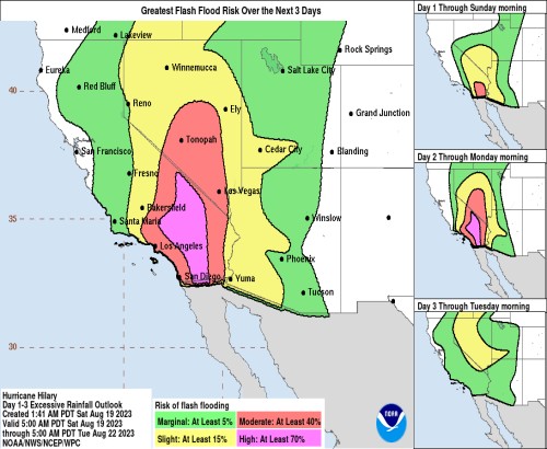
Hilary dumped more than half the average annual rain on some desert and mountain areas, including Palm Springs, which saw nearly 3 inches of rain by Sunday evening. Even though the center of Hilary has passed to the north, which was situated in western Nevada as of earlier this morning, it is expected to continue to bring heavy rain and the potential for more flooding and mud and rock slides. According to the National Hurricane Center (NHC), Hilary is expected to produce additional rainfall amounts of 2 to 4 inches, with isolated storm total amounts to 12 inches, across portions of Southern California and Southern Nevada through today. The NHC expects continued flash and urban flooding, including some that will be locally catastrophic. Further along Hilary’s track, the NHC forecasts 1 to 5 inches of rain across portions of Oregon and Idaho through Tuesday morning, resulting in localized, some significant, flash flooding.
There are some preliminary reports of critical infrastructure impacts, which so far are mostly in the energy and transportation sectors. In California, nearly 50,000 customers are without power. There have also been thousands of flight delays or cancelations affecting airports in California and elsewhere in the region.
Read more at the NHC, the National Weather Service, and CBS News.
Additionally, posted below is the FEMA Daily Operations Briefing, which provides more information on impacts and response and recovery efforts. WaterISAC stands ready to assist members with any unmet needs and can be contacted at an*****@*******ac.org and at (866)H2O-ISAC.
CISA and FEMA Convening ESF-14 Cross-Sector Business and Infrastructure Coordination Calls Beginning Today at 3 pm ET / 12 pm PT
For the latest on Hilary’s impacts and response and recovery efforts, CISA and FEMA invite infrastructure stakeholders to a Cross-Sector Business and Infrastructure partners conference series concerning Hilary beginning on Monday, August 21. These meetings will include an incident overview, the status of community lifelines, updates from available FEMA and CISA Regional personnel, and an open forum for questions and information sharing. These meetings will occur daily until further notice, utilizing the same link and bridge numbers. The meeting rooms will open 10 minutes prior to the scheduled time.
Date: Daily, starting Monday, August 21st until further notice
Time: 3 pm ET / 12 pm PT
Use the link below to join the call:
https://fema.zoomgov.com/j/1614360427
Passcode: 999
Or One Tap Mobile:
+16692545252,,1614360427# US (San Jose)
+16469641167,,1614360427# US (US Spanish Line)
Or Telephone:
Dial (for higher quality, dial a number based on your current location):
+1 669 254 5252 US (San Jose)
+1 646 964 1167 US (US Spanish Line)
+1 669 216 1590 US (San Jose)
+1 415 449 4000 US (US Spanish Line)
+1 551 285 1373 US (New Jersey)
+1 646 828 7666 US (New York)
Webinar ID: 161 436 0427
International numbers available:
https://fema.zoomgov.com/u/aclPUK4kAb
Business and infrastructure partners are also invited to access the FEMA National Business Emergency Operations Center (NBEOC) Dashboard via the following link:
https://fema.connectsolutions.com/nbeoc23/
August 20, 2023
As of 0800 PDT, the National Hurricane Center (NHC) reports Hilary has been downgraded to a tropical storm, with maximum sustained winds near 70 mph, and was located about 220 miles southeast of San Diego, CA. On the forecast track, the center of Hilary will move near or over the northern portion of the Baja California peninsula during the next few hours, and then move across southern California this afternoon. Weakening is expected, but Hilary is expected to remain a tropical storm before it reaches southern California.
Intense heavy rainfall associated with Hilary is expected across the southwestern U.S. through early Monday morning. Rainfall amounts of 3 to 6 inches, with isolated maximum amounts of 10 inches, are expected across portions of southern California and southern Nevada leading to dangerous to catastrophic flooding. Across portions of Oregon and Idaho, rainfall totals of 1 to 3 inches with local maxima to 5 inches are expected through Tuesday morning, resulting in localized, some significant, flash flooding. Additionally, in terms of high winds, tropical storm conditions are expected to begin in southern California this afternoon. Winds could be particularly strong and gusty in and near areas of elevated terrain. Higher gusts are expected well inland and will persist even after the system becomes post-tropical. A couple tornadoes are possible through this evening over southeast California, western Arizona, southern Nevada, and far southwest Utah.
For the latest updates on Hilary, visit the NHC. Additionally, posted below is the FEMA Daily Operations Briefing, which provides more information on the forecast for Hilary. WaterISAC stands ready to assist members with any unmet needs and can be contacted at an*****@*******ac.org and at (866)H2O-ISAC.
August 19, 2023
The National Hurricane Center (NHC) forecasts Hilary, currently a category 4 hurricane with maximum sustained winds near 130 mph located in the Pacific Ocean about 240 miles southwest of the tip of Mexico’s Baja California peninsula, will move across southern California Sunday afternoon and Sunday night. By that time, it is expected to have weakened to a tropical storm, but it will still likely bring heavy rain and flooding, especially to parts of southern California and southern Nevada, as well as elsewhere in the southwestern and western U.S. These impacts are expected to begin later today and last at least until Monday. Preparations for the impacts of flooding from rainfall should be completed as soon as possible.
According to the NHC, heavy rainfall in association with Hilary is expected across the southwestern U.S., peaking on Sunday, and possibly lasting through Monday. Rainfall amounts of 3 to 6 inches, with isolated amounts of 10 inches, are expected across portions of southern California and southern Nevada. Elsewhere across portions of the western U.S., rainfall totals of 1 to 3 inches are expected, resulting in localized flash flooding.
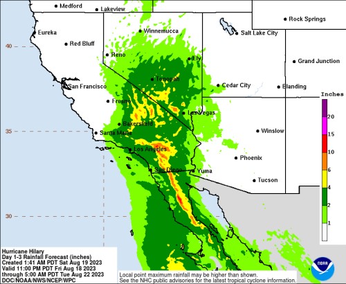
In the southwestern U.S. especially, flash, urban, and arroyo flooding is expected, according to the NHC. Dangerous and locally catastrophic flooding will be likely from tonight into Monday.
In addition to the impacts of rain and flooding, Hilary is expected to bring high winds. The winds could be particularly strong and gusty in and near areas of higher terrain. Additionally, a tornado or two may occur Sunday over parts of the lower Colorado River Valley, Mojave Desert, and Imperial Valley regions.
For the latest updates on Hilary, visit the NHC. Additionally, posted below is the FEMA Daily Operations Briefing, which provides more information on the forecast for Hilary. WaterISAC stands ready to assist members with any unmet needs and can be contacted at an*****@*******ac.org and at (866)H2O-ISAC.
August 17, 2023
Members in the Southwest, particularly in parts of California, Arizona, and Nevada, should monitor Hurricane Hilary and prepare for the potential for impacts this weekend into Monday. Heavy rain and flash, urban, and arroyo flooding are possible.
Earlier today Hilary was located in the Pacific Ocean, approximately 500 miles south of the tip of Mexico’s Baja Peninsula. Hilary is strengthening rapidly, with maximum sustained winds near 85 mph or greater, and is expected to become a major hurricane later today. Hilary is predicted to pass over or near Baja California first before moving over the southwestern U.S. At that time, perhaps early Monday morning, Hilary may have weakened and be a topical storm. Heavy rainfall in association with Hilary is expected to impact the Southwestern United States from Friday through early next week, peaking on Sunday and Monday. Rainfall amounts of 2 to 4 inches, with isolated amounts in excess of 8 inches, will be possible across portions of southern California and southern Nevada. Additionally, although it is too soon to determine the magnitude and location of wind impacts, members should prepare for the potential for these hazards as well. Read more at the National Hurricane Center.